Data and Site information (Cape Hedo)
General information
Location: 26.867N, 128.248E, 65 m a.s.l.
Site owners for SKYNET-related facilities:
Hitoshi Irie and Tamio Takamura (CEReS/Chiba-U.)
Okinawa denryoku (沖縄電力)
Data
Sky radiometer POM01
2003
2004
2005
2006a 2006b
2007a 2007b
2008
2009
2010
2011
2012
2013
2014
2015
2016
2017
2018
2019
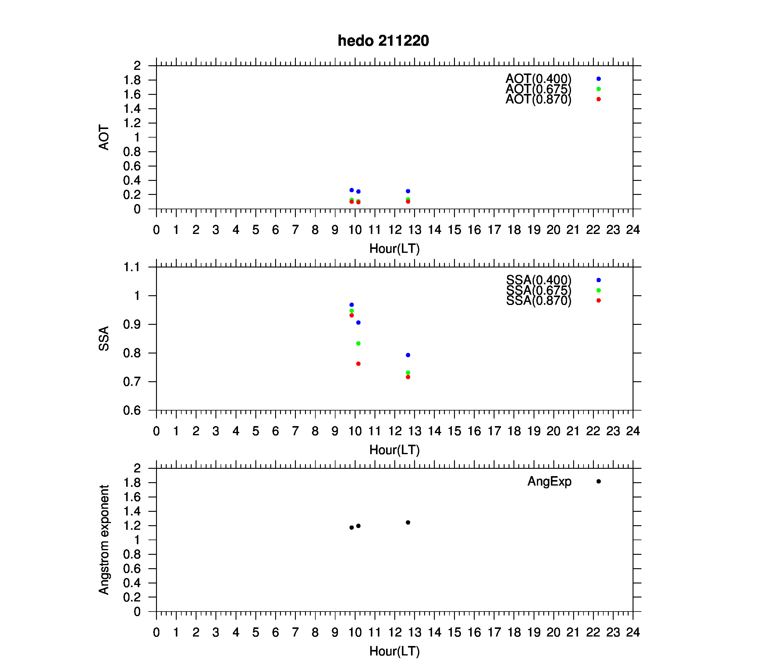
2020
2021
Sky radiometer POM02
2003
2004
2005
2006
2007
2008
2009
2010
2011
2012
2013
2014
2015
2016
2017
2018
2019
2020
2021
Microwave radiometer
2005 2006 2007 2008 2009
2010 2011
Global solar radiation
2005 2006 2007 2008 2009
2010 2011 2012 2013 2014
2015 2016 2017 2018 2019
2020 2021 2022 2023 2024
Direct solar radiation
2005 2006 2007 2008 2009
2010 2011 2012 2013 2014
2015 2016 2017 2018 2019
2020 2021 2022 2023 2024
Infrared radiation (downward) measured by CG4
2010 2011 2012 2013 2014
2015 2016 2017 2018 2019
2020 2021 2022 2023 2024
Infrared radiation (downward) measured by PIR
2005 2006 2007 2008 2009
2010 2011 2012 2013 2014
2015 2016 2017 2018 2019
2020 2021 2022 2023 2024
Temperature
2005 2006 2007 2008 2009
2010 2011 2012 2013 2014
2015 2016 2017 2018 2019
2020 2021 2022 2023 2024
Relative humidity
2005 2006 2007 2008 2009
2010 2011 2012 2013 2014
2015 2016 2017 2018 2019
2020 2021 2022 2023 2024
Wind direction
2005 2006 2007 2008 2009
2010 2011 2012 2013 2014
2015 2016 2017 2018 2019
2020 2021 2022 2023 2024
Wind speed
2005 2006 2007 2008 2009
2010 2011 2012 2013 2014
2015 2016 2017 2018 2019
2020 2021 2022 2023 2024
Skyview
Past imageries
History
- Mar. 12, 2019: AERONET/CIMEL observation started (data1, data2).
- Feb. 22, 2018: Skyview observations by a new instrument (PSV-100W2) started.
- Feb. 21, 2018: POM-02 observations resumed.
- Mar. 18, 2015: Some data for 2015 are now available.
- Mar. 16, 2015: Radiation, meteorology, and microwave radiometer data are now available.
- Jan. 29, 2015: This is still a tentative version.